I have an update on the long ongoing discussion regarding sending and receiving objects relative to different Reference Points, including:
Internal origin (default for all connectors)
Project base point (Revit)
Survey point (Revit)
Shared coordinates (Civil3D, not yet implemented)
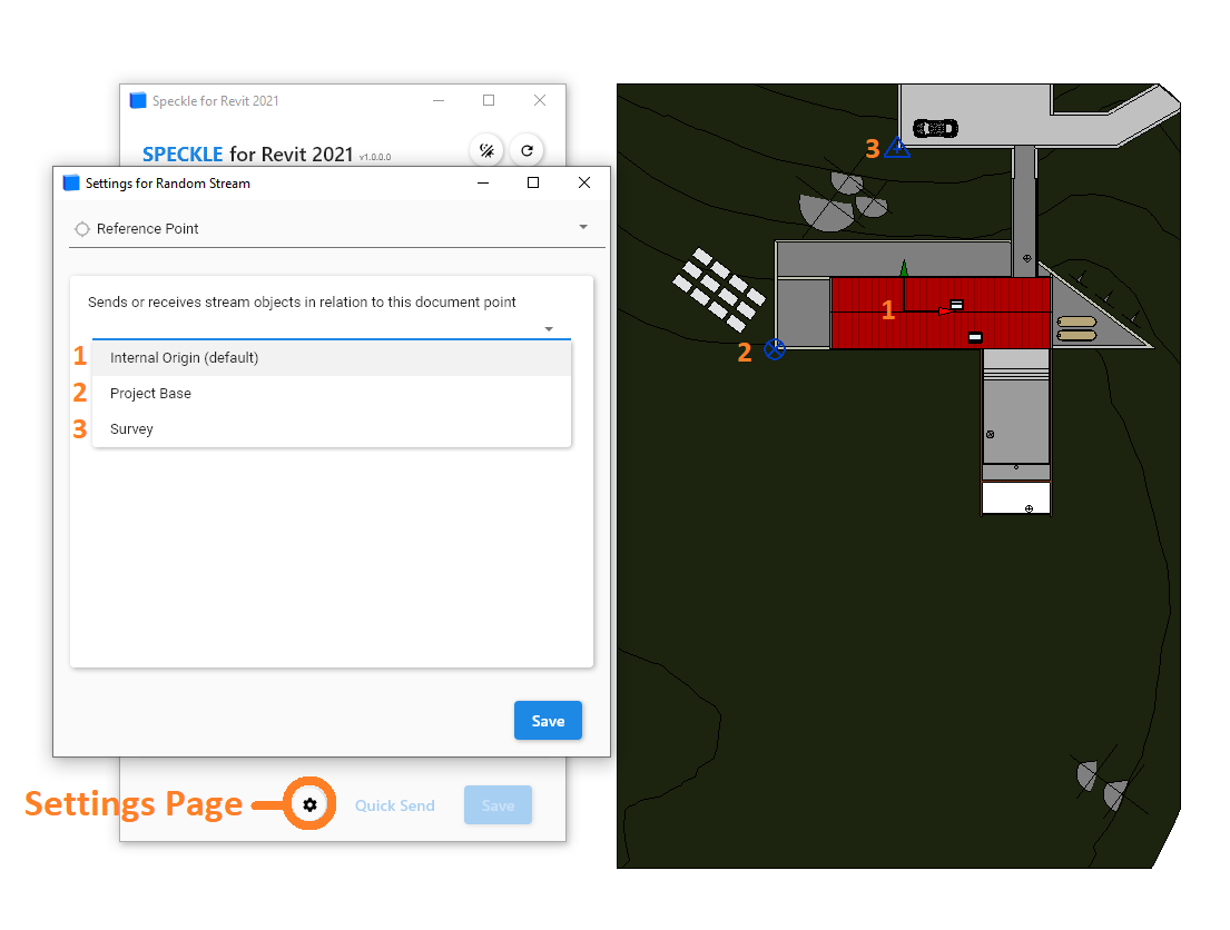
We’ve introduced a Settings page in the new Desktop UI2 that now allows you to select which Reference Point you want to send or receive your geometry in relation to. This has been implemented in Revit as a preliminary test, with Civil3D and maybe Bentley OBD down the line if people find this feature useful.
Previously, the Revit connector by default sends and receives all elements relative to the Project Base Point, which was causing some coordination issues especially with civil engineers that care more about the Internal Origin or Survey Point. Now, by default all objects are sent and received relative to the Internal Origin unless another reference point is selected.
Here’s an example of sending the Revit sample house using the different Reference Point options, and how they’d be received in an application that only has an Internal Origin option:
Currently, these settings are stored locally which means the reference points are pulled from your file directly and their coordinates and rotations are not stored anywhere on your stream or in the commit you create.
I can see this potentially causing some confusion in keeping track of how your objects were transformed on sending - we’re open to feedback on how you guys are actually using these custom reference points in your workflows and potential ways we can improve this feature!
Some first questions:
Would you like access to some global variable for your custom project points?
Would including the selected reference point in the commit (the name, coordinates, and rotation/transform information) be useful at all?
Thanks for being patient as we roll out these updates!
Sorry I am variable active here Functionality looks very cool!
I personally love the fourth option called ‘Shared Coordinates’ as the position of the ‘reference points’ is not always aligned to the origin of the coordinate system anyway.
As for the commit to the stream, it is always best to have the reference + real world coordinates + relative coordinates + rotation to north and the coordinate system applied (so basically all ‘Site’ information) included so that you can always transform it to the correct location in the WCS.
You could argue that for revit and civil, you can align the Revit ‘Internal’ site and coord system to the ‘WCS’ of Civil3D
Thanks for this feature. Regarding your questions at the end regarding accessing the project points. Having these available in the commit would be very useful indeed - in particular the project survey point as without it you can’t federate models into a geospatial context which have varying survey points.
Having this information included in the “Project Information” section or somewhere similar would be really appreciated.
Also, there are various discussions about geopositioning and CRS management here on the forum. Commit vs Stream Globals. Your input will be welcomed @tlewis.
Definitely, this makes sense - we’ve been floating around the idea of packaging certain project information with every commit anyways, so reference points may be a good first test run for that Will keep you updated!
I would say the most important information for geolocating a model would be the true north rotation, coordinate reference system and the survey point in Revit. Even if the coordinates of the model are not in the real-world coordinate system, it would be great to have a point that can be used to translate the model into its location, similar to IfcMapProjection in IFC files.

 Functionality looks very cool!