I’m taking a look at the Geospekle and the perks of its features!
How does the ‘immediate geolocated preview of any CAD/BIM model’ actually work?
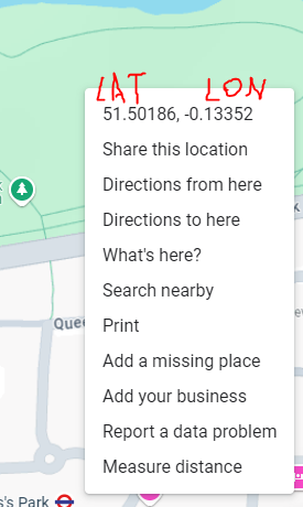
One definetly needs the lat and lon data for the URL, but can someone provide a few instructions on how tolocate the model precisely?
Is there some refenrence point that one has to add to rhino before sending it?
Hi @justa !
We are working on making the experience more integrated, so you can use the models from CAD software like Rhino and have minimum actions to geolocate it. As of now, in your Rhino canvas the (0,0,0) point is your desired location on the map. If your project doesn’t specify the coordinate system or the project origin, you can figure it out manually even on Google maps, and then set it as the “lat” and “lon” attributes in the geo.speckle.systems URL (e.g. https://geo.speckle.systems/?speckleUrl=https://app.speckle.systems/projects/64753f52b7/models/338b386787&lat=-0.031405&lon=109.335828 - this is a Rhino model)
If your project doesn’t specify the coordinates explicitly, then you are the one who can decide on the location!
Also, the geo.speckle.systems URL will always pick up the latest version of your model so you can use the same link all the time, while keep pushing new versions from Rhino